
CICE Collaboration Extending Sea Ice Prediction From Days to Decades

You might say that ice runs in Elizabeth Hunke’s blood.
The U.S. Department of Energy scientist who created the nation’s premier model used by NOAA, the U.S. Navy, and many scientists to predict sea ice got a taste for ice as a child.
The daughter of a Coast Guard officer, Hunke grew up around sea ice in Cordova, Alaska, where her father tended buoys in the chilly waters of Prince Edward Sound. Her father was also part of the Coast Guard ice patrol when her family lived near Boston, tracking icebergs to warn ships of lurking hazards.
For more than two decades, Hunke has worked at the Department of Energy’s Los Alamos National Laboratory to design, create and improve a model used to predict sea ice extent, thickness and movement in both the Arctic and Antarctica.
From the beginning, Hunke understood that collaboration was the key to improving this model, called CICE. Since its inception, the Department of Energy’s Office of Biological and Environmental Research (BER) Climate and Environmental Sciences Division (CESD) has supported the development and maintenance of the CICE model.
The Navy began contributing to the model in the 1990s. Then scientists at the National Center for Atmospheric Research joined the effort, expanding the community of researchers. More recently NOAA instigated a more formal collaboration process. NASA researchers and the Canadian government also use and contribute to the model.
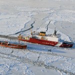
Increasing Ship Traffic Boosts Need for Forecasts
As Arctic sea ice declines more rapidly, the demand for improved prediction is increasing.
“During this period when ice is fluctuating a lot, there are many more attempts to get ships through it,” said Hunke. “This also presents more challenges for search and rescue.”
Arctic communities depend on sea ice as a platform for hunting, a roadway for transportation and a buffer for severe coastal storms. The military needs accurate predictions for today’s mission and to plan for building and operating the ships and submarines of the future. More industries working in the Arctic, including energy development, shippin, and tourism, depend on sea ice forecasts.
New Satellite Data Improve Forecasts
Ice prediction and modeling advances rely on satellite observations.
NOAA’s newest satellites have increased the frequency, resolution and information on sea ice used in the CICE model, which also draws on observations from buoys, ships and aircraft. NOAA’s new polar-orbiting satellite, NOAA-20, observes sea ice almost continually down to less than a quarter mile resolution. It uses moonlight to observe ice at night, so important in a region where it is dark a large part of the year.
NASA will be launching ICESat-2 later this year, a laser altimeter that will allow researchers to monitor sea ice thickness with unprecedented resolution and, for the first time, throughout the year. No other satellite has been able to obtain sea ice thickness during the summer months, which is the most critical season for Arctic shipping.
The National Ice Center, operated by the Navy, Coast Guard and NOAA, uses the CICE model to create sea ice forecasts for the Arctic, Antarctic, Great Lakes, Chesapeake Bay, Delaware Bay and Long Island Sound.
NOAA’s goal is to add sea ice prediction to the next generation Global Forecast System. Improving sea ice prediction is also a priority of the multi-agency federal effort called the National Earth System Prediction Capability, which aims to accelerate the short and long-term prediction of weather, climate, oceans and sea ice.
This article is courtesy of NOAA, the National Oceanic and Atmospheric Administration. Read the original story on the NOAA website.