Spatial Discrepancies in Cloud Radiative Effects Between Large-scale Datasets and In-situ Measurements over Greenland
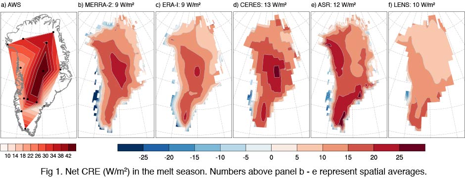
Arctic clouds can profoundly influence surface radiation and thus surface melt. Over Greenland, these cloud radiative effects (CRE) vary greatly with the diverse topography. To investigate the fidelities of assorted platforms, we evaluate CRE spatial distributions from five well-known datasets including a satellite product, two global and one regional reanalysis, and a global climate model against estimates from 21 automatic weather stations (AWS). Although the spatial averages of net CRE from these five datasets are all around 10 W/m2, their spatial distributions contrast. MERRA-2, ERA-Interim, and CERES agree with AWS: net CRE generally decreases with elevation, forming a “warm center” distribution (Fig. 1 a to d). The NCAR Arctic System Reanalysis (ASR) and the CESM Large ENSemble community project (LENS) show strong warming in the south and northwest, forming a “warm L-shape” distribution (Fig. 1 e and f). Discrepancies are mainly caused by longwave CRE in the accumulation zone. MERRA-2, ERA-Interim, and CERES successfully reproduce cloud fraction and its dominant positive influence on longwave CRE in this region. Longwave CRE from ASR and LENS correlates strongly with ice water path rather than cloud fraction or liquid water path. Moreover, ASR overestimates cloud fraction, and LENS underestimates liquid water path substantially, comparing to in-situ measurements at Summit, Greenland. CALIPSO also exhibits a “warm L-shape” CRE spatial distribution (van Tricht et. al., 2016), probably caused by its sparse spatio-temporal sampling. The “warm center” CRE spatial distribution established from in-situ measurements indicates the role of clouds as a mediator in surface melt over Greenland. Clouds warm the bright and cloudy Summit area the most, where surface melt is very scarce. Clouds cool the dark and cloudy coasts, especially in the west, where heavy mass loss occurs.
Our study provides ground truth to determine the actual spatial distribution of CRE over Greenland, highlights the most important factors for successfully reproducing CRE on large scales, and provides a convenient methodology to evaluate CRE estimated from large-scale datasets. We will include evaluations of more recent datasets such as ERA5, CESM 2.0, and E3SM simulations at AGU 2018.