
Assessing Climate Impacts on Coastal-Urban Flooding Through High-Resolution Barotropic and Baroclinic Ocean Coupling
Project Team
Principal Investigator

The primary objective of this project is to bridge the divergent scales between the global climate drivers of sea level rise and the local coastal impacts of extreme events in the Energy Exascale Earth System Model (E3SM). This objective will be accomplished by unifying two classes of models: Earth system models (ESMs) and barotropic coastal flooding models. ESMs incorporate interactions between separate geophysical systems. Because of their complexity, however, the 3D ocean model components of these ESMs operate at a resolution far coarser than what is needed to resolve complex coastal regions. On the other hand, while 2D barotropic coastal flood models efficiently describe tidal and storm surge processes at high resolution, they neglect density effects and lack connections to the climate drivers associated with sea level rise.
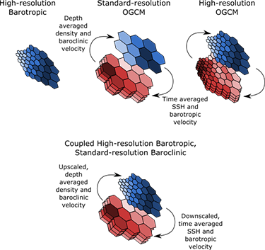
Our project extends the mode-splitting approaches that ESM ocean models currently use to separate fast, barotropic free-surface waves from slower, density-driven baroclinic flow. Such approaches typically work by evolving the baroclinic mode at a larger time step than the barotropic mode. In contrast, we will employ mode splitting in space as well as time, such that the barotropic and baroclinic modes are two-way coupled between different resolution meshes.
This coupling will enable an increase in the horizontal resolution of the 2D barotropic mode, allowing the model to resolve tides and storm surge in estuaries and rivers without the expense of refining the 3D baroclinic mode to coastal scales. With this new capability, E3SM will be able to resolve coastal-urban flooding processes due to sea level rise, tides, and storm surge in long-term climate simulations, enabling comprehensive studies of the effects of climate change on extreme water levels in coastal-urban systems.
The project will focus on the major urban centers of the United States Mid-Atlantic region, with a particular emphasis on Baltimore, Philadelphia, and New York City. The coastal-urban regions in this area experience exposure to extreme flooding and associated risks related to the combination of tropical cyclones, tides, and sea level rise under climate change. This project seeks to provide local stakeholders with a fully integrated assessment of future flooding risks in these communities.