
Climate Model Development and Validation – Mesoscale Convective System (CMDV-MCS)
Project Team
Principal Investigator
Project Participant
The Climate Model Development and Validation (CMDV) – Mesoscale Convective System (MCS) is a project titled "Use of Remote Sensing and In-Situ Observations to Develop and Evaluate Improved Representations of Convection and Clouds for the ACME Model," sponsored by the U.S. Department of Energy’s (DOE’s) Office of Biological and Environmental Research (BER) to develop and validate the DOE’s Accelerated Climate Model for Energy (ACME) model capability in simulating MCSs.
MCSs are one of the most climatically significant forms of convection. They influence the climate system through (1) releasing latent heat that drives the general circulation, (2) providing the dominant source of precipitation in many regions, (3) redistributing and removing water, clouds, and aerosol, and (4) affecting the transfer of radiation through the atmosphere.
There are many significant challenges in global simulations of MCS features, including initiation, propagation, cloud phase (liquid, mixed, or ice), diurnal cycles of temperature and precipitation, temperature and precipitation extremes and cloud-aerosol interactions. Addressing the challenge of simulating MCSs in global atmosphere models is important for global weather forecasting, as well as climate simulation. Our hypotheses are that:
- global climate model (GCM) simulations with improved treatment of certain convective cloud processes can better capture MCS features at various resolutions,
- the probability density functions (PDFs) of precipitation and temperature, extreme statistics, cloud phase, cloud radiative forcing, and aerosol-cloud interactions will be much better simulated with microphysical parameterizations considering evolution of hydrometeor size distribution and improved ice nucleation, and
- parameterization developments based on observations over the central U.S. will contribute to improving the simulated climate elsewhere.
Approach
To test the validity of these hypotheses, we propose to use ARM ground-based and aircraft in-situ data, NOAA NEXRAD, satellite observations, as well as extended domain Large Eddy Simulation (LES) and Limited-Area Model (LAM) simulations over the central US, to guide the development and evaluation of:
- representations of convection in the ACME global model using the Cloud Layers Unified By Binormals (CLUBB) scheme and the quasi-3 dimensional (Q3D) Multiscale Modeling Framework, and
- microphysical treatments based on both bulk and bin approaches.
Simulations
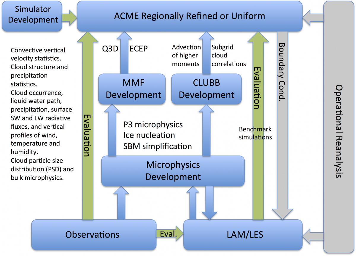
During our project, we will use cases chosen from the Midlatitude Continental Convective Clouds Experiment (MC3E) and the Plains Elevated Convection at Night (PECAN) for detailed analyses of MCS lifecycles. LES and LAM studies of selected cases will be carried out over the region to improve understanding of MCS features and serve as benchmarks guiding parameterization development and to assess ACME model simulations.
Very high resolution regionally-refined versions of the ACME model focused on the central U.S. nudged by analysis datasets will be used to:
- evaluate climate model treatments of these processes as a function of scale, and
- act as a vehicle to implement new (or improve existing) formulations.
Model simulations will be carried out and evaluated with month-long observations of MC3E, long-term statistics of MCS features at the ARM SGP site, and satellite active sensors (TRMM/GPM, CloudSat, and CALIPSO). To more accurately and quantitatively evaluate model simulations, instrumental simulators for ground-based and space radars and lidars will be developed and used to compare model outputs with observations. When assessment of the new parameterizations for the continental USA (and SGP) region suggests improvement, the ACME model will be configured to explore the consequences for global simulations (e.g., MJO, ITCZ, ENSO, monsoons) at different grid-spacings using a uniform grid.
Deliverables
The grand deliverables of the proposed research are:
- new and improved convection and cloud microphysics parameterizations for GCMs, and
- a version of the ACME model that can better predict meso-scale phenomena.
The proposed research would produce a large impact on the paradigm of climate modeling evaluation by providing a framework that uses comprehensive observational datasets at different scales to understand climate-related processes and evaluate representations of those processes in state-of-art climate models.
The project spans a 3-year period from FY2017-2019, with a collaboration team consisting of three national labs (PNNL, BNL, and SNL) and four universities (Colorado State U., U. Arizona, U. Wisconsin-Milwaukee, and U. Wyoming).