A Planetary-Scale Data–Model Integration Framework to Resolve Urban Impacts Across Scales and Examine Weather Extremes over Coastal U.S. Cities
Project Team
Principal Investigator
Urbanization leads to widespread modifications to the Earth’s land surface and directly impacts more than half of the total global population by influencing weather and climate. These impacts are expected to magnify in the future due to increased urbanization and greater rural-to-urban migration. Current generations of Earth System Models (ESMs) inadequately represent urban areas and processes. They either ignore urban land completely or treat cities like biologically inactive surfaces with discrete and crudely specified properties. These simplified representations are insufficient for capturing variability in urban impacts on weather and climate across global cities. The limited number of ESMs that do represent urban areas do not account for temporal changes due to urban evolution, which is the combined result of urban expansion and varying surface properties over time. This urban evolution will become increasingly important in the future as the world keeps urbanizing. These issues are particularly relevant for complex coastal–urban environments, characterized by strong land-to-water spatial gradients in both surface and atmospheric variables. Current-generation ESMs cannot sufficiently resolve interactions between urbanization and coastal processes, which can have potentially critical impacts on weather and climate, especially during extreme events.
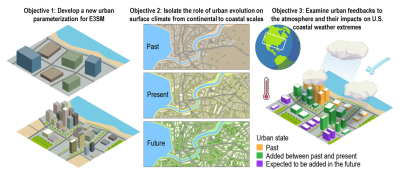
To address these model deficiencies, the proposed research aims to develop a globally consistent data–model integration framework for the Department of Energy’s Energy Exascale Earth System Model (E3SM) to resolve urbanization and its feedbacks to the atmosphere across multiple spatial and temporal scales with a focus on coastal U.S. cities. To accomplish this, the E3SM Land Model will be improved to incorporate more accurate urban characteristics and processes derived from planetary-scale satellite imagery and satellite-derived datasets, other gridded products, and machine learning (ML) techniques for recent past, present, and potential future scenarios. A range of urban-scale measurements from various sources will also be compiled to create a model testbed for quantifying uncertainties throughout the model development process. Beyond the importance of this testbed for this project, it will be an essential resource for the wider urban climate community. Finally, a hierarchy of E3SM simulations, both coupled and uncoupled, across scales constrained by ML algorithms will be run to examine km-scale urban climate variability and generate groundbreaking insights regarding coastal–urban interactions. Overall, this work will not only develop an advanced urban parameterization for the next generation of ESMs but will also generate tools and datasets that can better assess and advise climate adaptation and mitigation strategies as we prepare for a warmer and more urban future.

