Can DOE’s Flagship Earth System Model Skillfully Recreate Historic Flood Events?
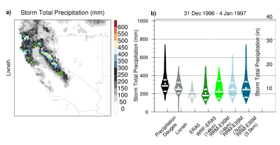
We used a storyline approach to recreate California's flood of record, the New Year's flood of 1997, using a regionally refined Earth system modeling approach (RRM-E3SM). This is the first time RRM-E3SM has been used to systematically assess how both forecast lead time and model horizontal resolution influenced forecast skill for a key western United States hydrometeorological extreme event. Across formal measures of forecast quality and value, RRM-E3SM (3.5 km) had the highest skill in recreating the 1997 flood compared with lower-resolution versions of E3SM validated against in situ, reanalysis, and gridded climate products. Overall, RRM-E3SM (3.5 km) forecast ensemble average skill in recreating the 1997 flood gives confidence in its utility to support resiliency planning for extreme events.
The 1997 California New Year's flood event caused over a billion dollars in damages. Extreme precipitation, snowmelt, and saturated soils produced heavy runoff causing widespread inundation in the Sacramento Valley. This storm has become a central part of guiding efforts to reduce flood risks. It is paramount to explore how well our Earth system models are fit for purpose in simulating such events, particularly compound extreme events (e.g., rain-on-snow) like the 1997 flood. Testing ensures that models provide value in anticipating and planning for future flood events. This is particularly important given the changing climate.
We evaluated the Department of Energy's flagship Earth system model, the Energy Exascale Earth System Model with regionally refined mesh capabilities (RRM-E3SM), in its ability to recreate the weather and flood characteristics of the 1997 flood. The model resolution, important for resolving mountain terrain and storm interactions, and forecast lead time, important for storm progression accuracy, are assessed. The multi-forecast average from the highest-resolution model best recreates the observed precipitation, snowpack changes, and certain flood characteristics. Our findings provide confidence that the highest resolution model could be used to study how a 1997-like flood event would be altered in a warmer world.

