Compound Hazard of Freezing Rain and Wind Gusts Across the Continental United States
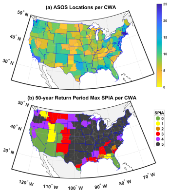
The co-occurrence of freezing rain, ice accumulation and wind gusts (FZG) poses a significant hazard to infrastructure and transportation. However, quantification of the frequency and intensity of FZG is challenged by the lack of direct icing measurements. Here we generate a spatial explicit atlas of this compound hazard using energy balance models. First, we evaluate the fidelity of the ice accumulation models and then apply the best model to compute the magnitude of this compound hazard. Time series of hourly freezing rain, ice accumulation and wind gusts (expressed on the Sperry–Piltz Ice Accumulation (SPIA) index scale) at each NWS Automated Surface Observing Station (ASOS) across the Continental United States (CONUS) are computed and used to (i) derive a geospatial atlas of this hazard including the 50 yr return period event intensities for each US state and NWS CWA area using a superstation approach, and (ii) describe storylines of significant events in terms of meteorological drivers and socioeconomic impacts. The highest values of SPIA during the 18-year study period occur in a region extending from the Southern Great Plains over the Midwest into the densely populated Northeast. States in these regions also have a high 50-year return period maximum radial ice accumulation of 3–5 cm and co-occurring wind gusts >30 ms−1.
The geospatial atlas of FZG compound hazard presented herein is designed to inform infrastructure design codes and aid in hazard mitigation planning. The FZG timeseries can also be used to condition a statistical downscaling model for examining long-term variability/trends in frequency and/or severity and derive future projections.
The compound hazard comprising freezing rain, ice accumulation, and wind gusts is a major source of socio-economic losses across North America and beyond. We present the most comprehensive assessment of ice accumulation models from freezing rain performed for CONUS to date. It is based on 18 years of 5-minute observations of the predictors from 883 ASOS locations. Direct ice accumulation measurements are generally not available, so this analysis first evaluates a suite of energy-balance based ice accumulation models. Ice accumulation estimates from the best model are then combined with surface wind gust observations to derive hourly time series of hazard magnitude at 883 ASOS stations. From these time series, we generate a uniquely detailed and robust geospatial atlas of the compound hazard posed by freezing rain-ice accumulation-and wind gusts for CONUS. Validation of derived SPIA index damage estimates exhibits relatively high fidelity based on Storm Reports of individual societally relevant storylines.

