
Localized Grid Refinements in the CAM5-Spectral Element Model Improve Regional Climatologies
High-resolution climate modeling promises to reveal new insights into the many multi-scale interactions in the climate system. At grid resolution around 30 km and finer, meso-scale phenomena like topographically-forced local wind patterns, meso-scale convective systems or tropical cyclones, start to become resolved and their upscale effects on the general circulation can be investigated. However, high-resolution climate modeling is costly from a computational viewpoint, and so far only very few global modeling studies with grid spacings of 30 km and below have been conducted. Therefore, we promote the use of variable-resolution (VR) grids that lower the computational demand while providing high-resolution regional climate information over areas of interests.
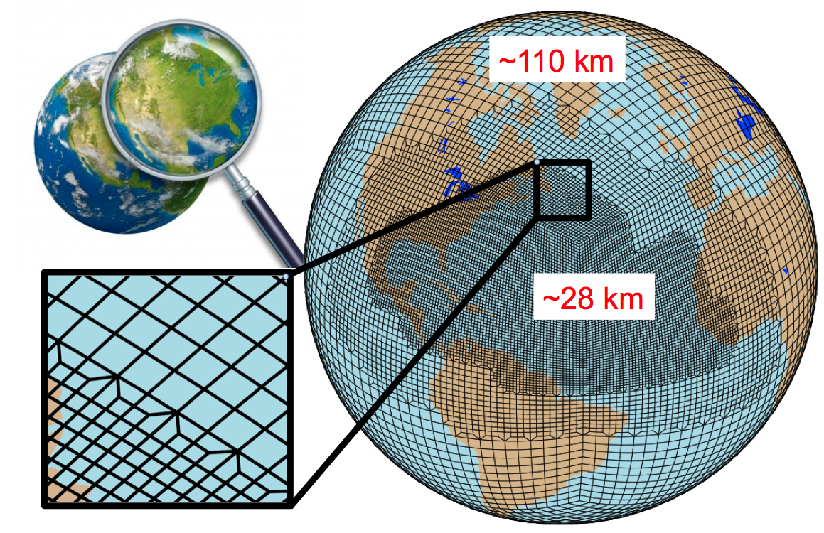
In the publication entitled ‘Effects of Localized Grid Refinement on the General Circulation and Climatology in the Community Atmosphere Model’ (CAM) a team of scientists from the University of Michigan (Colin Zarzycki, Christiane Jablonowski, Diana Thatcher) and Sandia National Laboratories (Mark Taylor) investigate the impact of a regionally-refined nested area in the DoE/NCAR CAM5 Spectral Element (SE) model. In particular, they zoomed into the North Atlantic Ocean basin with a 0.25 degree (28 km) mesh which was embedded within a 1 degree (111 km) global grid. Two 23-year simulations with prescribed sea surface temperatures and sea ice were conducted (with and without the refined nest) in order to investigate their climatology and shed light on the upscale effects in the VR simulation.
They found that the addition of a refined patch over the Atlantic basin does not noticeably affect the global circulation. In the area where the refinement is located, large-scale precipitation increases with the higher resolution. This increase is partly offset by a decrease in precipitation resulting from convective parameterizations, although total precipitation is also slightly higher at finer resolutions. Large-scale equatorial waves are not significantly impacted when traversing multiple grid spacings. Despite the grid transition region bisecting northern Africa, local zonal jets and African easterly wave activity are highly similar in both simulations. The frequency of extreme precipitation events increases with resolution, although this increase is restricted to the refined patch. Topography is better resolved in the nest as a result of finer grid spacing. The spatial patterns of variables with strong orographic forcing (such as precipitation, cloud, and precipitable water) are improved with local refinement. Additionally, dynamical features, such as wind patterns, associated with steep terrain are improved in the variable-resolution simulation when compared to the uniform coarser run. The results demonstrate the variable-resolution modeling with CAM-SE is free of numerical artifacts and has become a mature technique for regional climate studies.
The authors thank Peter Lauritzen (NCAR) for his assistance with the topography generation on VR grids, Chris Skinner (Stanford) for providing scripts regarding the African wave analysis, and Paul Ullrich (University of California, Davis) for contributing computing time to complete a subset of the simulations. The University of Michigan team was supported by the DoE Office of Science Awards DE-SC0003990 and DE-SC0006684. Mark Taylor was supported by the DOE BER work packages 12-015334 and 11-014996. Some of this work was completed during the ‘Multiscale Numerics for the Atmosphere and Ocean’ program at the Issac Newton Institute for Mathematical Sciences in Cambridge, United Kingdom. Portions of the data analysis were completed using the Community Earth System Model (CESM) Atmosphere Model Working Group (AMWG) Variability Package, available at www.cgd.ucar.edu/amp/amwg/vdiag/index.html.