Simulation of Diverse ENSO Teleconnections to Extremes in High Resolution Earth System Models
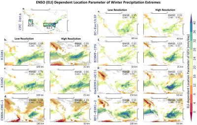
We evaluate seven state-of-the-art high-resolution (< 50km horizontal resolution) models for their simulation of the spatial diversity of El Nino Southern Oscillation (ENSO) associated sea surface temperature anomalies and its teleconnections to US winter season precipitation extremes.
High-resolution models are found to credibly capture diverse ENSO teleconnections as observed over Southeast and Southwest US. High-resolution models are generally found to improve upon their low-resolution counterparts largely due to the improved simulation of ENSO-dependent moisture transport, storm track activity, and vertical mass fluxes. Our results suggest that using high-resolution models can enhance seasonal forecasting of regional water cycles.
ENSO comes in many flavors with diverse spatial patterns of ocean warming and associated heavy tropical rainfall over the deep tropical Pacific. This ENSO diversity is one of the major reasons behind our limited understanding and prediction of its global impacts, particularly on climate extremes. A recent approach to characterize the full spectrum of ENSO using a simple index, namely the ENSO Longitudinal Index, shows promise in improving our understanding. Here, we use this new index to evaluate if new state-of-the-art high-resolution earth system models can capture the remote impacts of ENSO on US precipitation extremes in the winter using generalized extreme value theory. We find that some of these models can credibly simulate these ENSO teleconnections, across its many flavors, over the Southeast and Southwest US, and generally improve upon their low-resolution model counterparts. This is due to improvements in ENSO-dependent moisture transport, storm track activity, and vertical mass fluxes in high-resolution models.

