
When the Wind Comes Sweeping Down the Plain

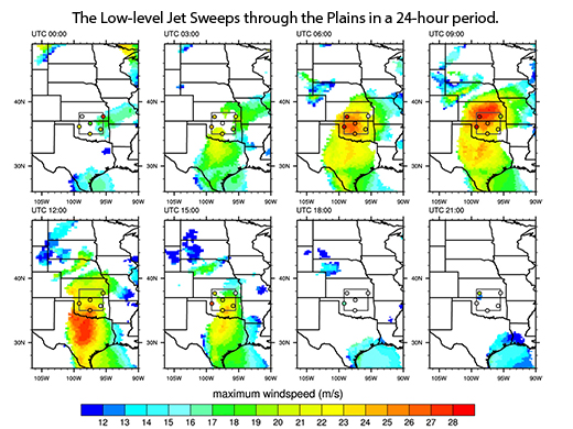
Residents of Oklahoma and other plains states are wise to the blustery seasonal force gusting nightly during warm springs and summers, carrying the moisture needed for rain. So emblematic for the region they wrote a song about it, the low-level jet is easy for people to recognize. Still, computer models struggle to capture its complexity. When the models underestimate the amount of water carried in by the jets, they are not good precipitation predictors.
To get more model accuracy, scientists often feed the models specialized datasets called reanalyses that bridge the gaps in measured observations. How well do these sets perform their proxy role? To find out, atmospheric experts at Pacific Northwest National Laboratory compared six reanalyses products against observational data from the U.S. Department of Energy's Atmospheric Radiation Measurement (ARM) Climate Research Facility in Oklahoma. The research pinpointed weaknesses that affect the models' ability to accurately predict jet frequency—a key piece of information tied to precipitation. The finding can help farmers, cowhands, and climate researchers alike.
The PNNL research team evaluated the features of the Southern Great Plains low-level jet above the ARM Climate Research Facility in Oklahoma using six popular reanalysis products:
- NCEP-Department of Energy Reanalysis 2 (NCEP2)
- NCEP Climate Forecast System Reanalysis (CFSR)
- ECMWF Re-Analysis (ERA)-Interim
- Japanese 25-year Reanalysis (JRA-25)
- Modern-Era Retrospective Analysis for Research and Applications (MERRA)
- North American Regional Reanalysis (NARR).
Next, the team evaluated the data using two sets of radiosonde data (see sidebar): the six-week Midlatitude Continental Convective Clouds Experiment (MC3E), and site data from a ten-year period spanning 2001 through 2010. They compared all five reanalysis products to MC3E observational data, and compared the NARR, MERRA, and CFSR only to the ten-year data.
This study is unique because they combined use of the six different reanalysis products, the MC3E data, and long-term ARM radiosonde data sets to understand the hydrological impact of low-level jets over the Great Plains.
While increasing the vertical and horizontal resolution of the models improved prediction of the low-level jets' frequency, the research zeroed in on some shortcomings: the reanalyses tend to overestimate wind speed between certain pressure levels and they place the "nose" of the jet at a higher-than-observed altitude. These shortcomings affected the models' ability to accurately predict the frequency of the jets.
Low-level jets can quickly ramp up to gale-force levels. And, if the frequency of low-level jets is underestimated, then the amount of moisture they carry will also be miscalculated. This could have implications for farmers watering crops and feeding livestock, or flood control and water resource decisions. The new research provides further insight into how moisture is transported by low-level jets.
For scientists, this research also breaks new ground by evaluating the datasets known as reanalysis products, to find their strengths and weaknesses.
"The various reanalysis products are commonly used to evaluate global simulations, especially when observations are not available," said lead researcher Dr. Larry Berg, PNNL atmospheric scientist. "So we are interested in understanding how closely they mimic observations."
This research was supported by the Office of Science of the U.S. Department of Energy as part of the Earth System Modeling program and used data from the ACRF. The Pacific Northwest National Laboratory is operated for the DOE by Battelle Memorial Institute under Contract DE-AC05-76RLO1830.