
The netCDF Operators (NCO): Automatic Remapping of Gridded Geoscience Data
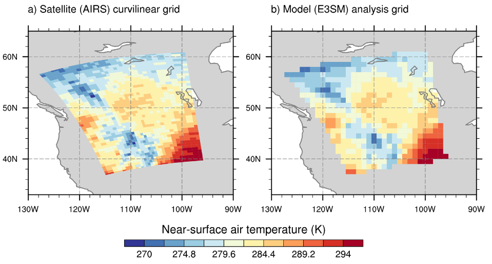
To analyze earth system models (ESMs) and evaluate their simulations relative to global, satellite-based observations, geoscientists must often remap data between different coordinate systems (or “grids”). Adding to the complexity, data are often provided in different formats. For instance, ESMs store data in the Network Common Data Form (netCDF) format, while NASA often stores satellite data in the Hierarchical Data Format (HDF).
The netCDF Operators (NCO) effort has developed the first software tool to automatically remap data expressed in diverse formats onto different grids. Previously, such remapping required familiarity with intricate mathematical operations and multiple tools. Now innovative NCO algorithms automatically identify the relevant grids, choose the appropriate mathematical options, and accurately remap the data with a single command.
Today’s researchers now can readily perform what was formerly a time-consuming and error-prone remapping task. NCO significantly eases intercomparison of ESM simulations with those of other models, and with satellite-based measurements. It thus expedites deeper understanding of geophysical processes and accelerates their improved representation in ESMs.